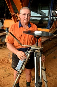
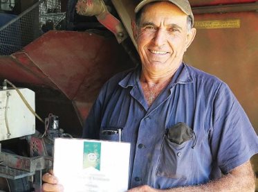
Natural Systems Management
By in

Natural Systems Management

Case Study
S-BMP-NSM-2013-002-01

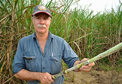
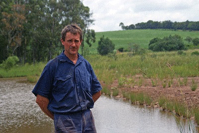
Adjoining the Babinda Creek, the Destro cane farm has used Reef Rescue funding and teamed up with the local Landcare group and Terrain NRM in projects to repair the eroded and undercut creek banks. Fixing the eroded banks and revegetating riparian zones reduces sediment loss, enhance water quality and the local environs.

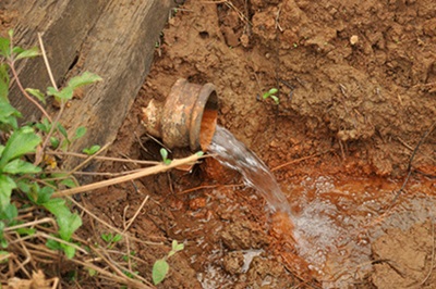
High rainfall and removal of vegetation from stream banks had created scoured creek banks and highly turbid water in Babinda Creek. Bank erosion in this sub-catchment is thought to contribute one tonne of sediment per hectare per year into the Great Barrier Reef lagoon.

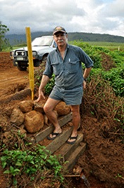
Stabilisation work to remediate severe erosion and resultant leaching of fine clay particulate subsoil involves battering or tapering the slope of the creek, then applying rock armour to hold the re-shaped creek bank before it is re-vegetated by Landcare with native riparian species. Mr Destro says “Once you’ve stabilised your bank you’ve always got good water, but the stuff on the banks grows too, you can grow trees or bushes which also play a part in slowing down and filtering the water.”

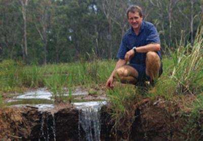
If previous results are any guide, the project stands a strong chance of success. Mr Destro notes that a re-vegetation site downstream that was funded via an earlier Reef Rescue catchment repair grant, has transformed in the year since the rapidly eroding creek bank was rebuilt with a similar process. Despite several floods, the majority of endemic trees planted on the re-shaped bank appear to be establishing themselves and while there is ongoing maintenance needed to keep weeds under control as the trees grow to form a canopy, the results so far are promising.

Re-vegetation of creek banks is ultimately a give-and-take affair for the grower. Tapering the creek bank in the up-coming project will mean relocating the headland 13m further away from the waterway, with the vegetation buffer on the bank acting as a sediment trap and nutrient filter. Mr Destro whose holdings span about 250 hectares says “I’ll lose a fair bit of land doing that but we’re here for the long haul.”

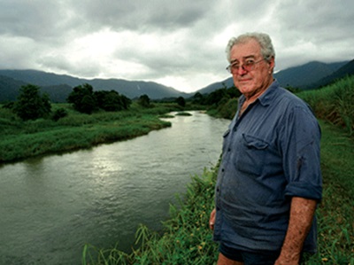
Fixing eroded banks and revegetating riparian zones reduces sediment loss, enhance water quality and the local environs

“The quicker the better, it’s frightening in some places down there to see what’s happening to the river.” “It involves us forking out money and that hurts, but because we want it – it is good for the property and the environment, we’ll stick our neck out. It’s paramount that we do it.”

Revegetating riparian zones and fixing eroded banks are positive steps being taken to minimise sediment and nutrient runoff and to improve the quality of water entering the Great Barrier Reef lagoon. Nowadays it’s a common sight to see tour groups of kayak adventurers paddling the upper reaches of Babinda Creek.

Irrigation and Drainage Management - #2
By in

Irrigation and Drainage Management - #2

Case Study
S-BMP-IDM-2013-002-01

At his cane farm in the foothills of magnificent Mount Bartle Frere, Ray Vicarioli has learnt to make a sustainable living from the land, while dealing with Mother Nature’s propensity to dish out weather in lavish extremes.

Ask the locals in the fertile country fringing the fast flowing Russell River, and they’ll tell you that when the clouds drop below the iconic ‘broken nose’ of Queensland’s tallest mountain that it’s about to rain.

Laughing, Ray adds: “and when the cloud’s above broken nose, rain is on the way.”

In a place where six metres of rain each year barely raises an eyebrow, it’s no surprise that drainage and soil hydrology can present great challenges, particularly on the more sloping paddocks approaching the mountainside.

On the Vicarioli’s 116 hectare property, a range of techniques have been employed to deal with the one raw material for which there is often a drastic oversupply – water.

Hilly paddocks have been contoured to reduce gradient and minimise water velocity. Sediment runoff has been limited by the application of silt traps.

Sophisticated sub-surface drainage systems have also been constructed to minimise nutrient volatilisation, maximise storage of nutrient in soils and largely eliminate chemical runoff into drains.

“If there’s any chemical in the water, it’s not going down into the creeks,” Mr Vicarioli said.

“With the seepage pipes, we’ll dig a trench probably a bit over a metre, or one point two metres deep, put 100 mm of sand on the bottom, put in a drainage pipe and fill to the top with more sand.

“Seepage coming through from the hills which normally just dams up along the headlands is removed through the sub-surface drain.”

While Mr Vicarioli consistently tests for nutrients in the creeks, the evidence of healthy waterways is readily visible.

Ray Vicarioli has implemented a range of techniques on his Cairns region farm to deal with an oversupply of water

Freshwater aquatic species that are sensitive to chemicals and require highly oxygenated water abound.

“The place is very alive, full of life, the little creek that runs through here is full of sooty grunter, mountain (jungle) perch and rainbow fish, eels, prawns, you name it,’’ Mr Vicarioli said.

“I have a meter which measures parts per million of nutrient, it goes down to about three hundred parts per million and I find no levels.’’

Over the years, Ray, wife Rosemary, son Ryan and daughter Lucy have also embraced Landcare initiatives and have taken an active involvement in riverbank restoration.

The other essential element of their philosophy is part of the creed for most growers in the wet tropics – make the most of every day, for tomorrow it will, almost surely, be raining.

While Mr Vicarioli consistently tests for nutrients in the creeks, the evidence of healthy waterways is readily visible

The Vicariolis have implemented sub-surface drainage systems to minimise nutrient volatilisation, maximise storage of nutrient in soils and largely eliminate chemical runoff into drains.

Irrigation and Drainage Management
By in

Irrigation and Drainage Management

Case Study
S-BMP-IDM-2013-001-01

Despite several rainy days, a marshy area through Neale Mittelheuser’s farm near Childers is now yielding about 100 ML a year of additional irrigation water for the farm.

“The catchment dam has a capacity of about 22 ML and it can fill within a few hours,” he says. “We started work on the project in 2008 and finished last year.

“The wetland was probably once a creek but over the years it has silted up and become a marsh,” says Neale.

“Water has always run through here and now we can collect it for irrigation.

“The water that runs into the catchment dam is from runoff and seepage, either from the watertable or a spring higher up the hill. We had the water tested and it is very good quality.”

The waterway leading through the farm to the dam is about 250 m long and covered with grass and trees.

Initially Neale thought they may build up the dam wall another three or four metres and back up more water but he decided against this plan, preferring to keep the vegetation as a filter for any silt that might come with the water.

The dam is about 15 m deep and Neale has installed a new pump and electric motor. Connecting the new dam to the existing mains pipe only required about 40 or 50 m of new underground pipe.

Neale expects to source about 100 ML from the dam each year, making a significant contribution to the irrigation supply for the farms.

“We have a good allocation on this red soil farm of 420 ML but the other farm only has 190 ML,” says Neale.

“Having this extra water means we can transfer water between the farms and have water when we need it.”

The project cost a total of about $60,000. Neale applied for, and was granted, $5000 from the federal government’s Reef Rescue project, and $10,000 from a wetlands funding package administered through the Burnett Catchment Care Association and CANEGROWERS Isis.

Neale Mittelheuser’s farm near Childers is now yielding about 100 ML a year of additional irrigation water

Neale farms in partnership with his father, Dudley, who comes up from Hervey Bay for a few days most weeks.

The red soil farm includes the 12 ha wetland area that has never been used for agricultural production. When mains irrigation came to the Mittelheuser’s farms in 1991 they changed the row direction and now most of the runs are 530 m long.

Above the waterhole there is a 250 m long waterway

They were one of the first growers in the Isis district to use Upton boom irrigators with two 80 m wide booms on the red soil and a 100 m wide boom at Farnsfield.

“In the early years we had a few problems with the booms tipping but now we have a groove in each headland for the front wheel to run along and I rarely even check them at night,” says Neale.

“They are such an efficient irrigation system. We only need a 30 HP motor to run them and we get good, even coverage of the block, even in 20–25 knot winds.”

The Mittelheusers have searched for groundwater on the Farnsfield farm to help supplement irrigation but did not find any useful quantities of water so having access to the water from the catchment dam has made a real difference.

In the recent rain the only erosion on the red soil farm was in the plant cane because the rest of the farm, with slopes as high as 30°, is well protected by a thick trash blanket.

Farm Business Management
By in

Farm Business Management

Case Study
S-BMP-BUS-2013-001-011

Farming in the Herbert River region for more than 90 years, Stephen Accornero’s family has seen a lot of advances throughout the sugarcane industry over the years.

Since his grandfather cleared land at Abergowrie to grow sugarcane in the 1950s, before the returned soldiers’ settlement package, the family farm has grown from one farm to three, and has significantly increased tonnages.

Now the Accornero’s combined farms at Forest Home, Abergowrie and Bambaroo harvest about 36,000 tonnes in a normal year. Today, Stephen, his wife Annalisa and their son Brenden run the family company’s on-farm and off-farm operations, with the help of one full time worker.

A growing business, Stephen says originally they expanded the family farm by buying out other neighbouring cane farms as they came onto the market, and also then slowly developing the cattle property into a cane farm.

“It works as we can work on one farm when it is raining on another,” says Brenden.

Stephen says Annalisa is an integral part of their business, and in addition to working as a finance officer for Rabobank, she provides invaluable advice on-farm.

“Annalisa didn’t grow up in farming but she is on the ball when it comes to any of our financial decisions about borrowing. She has the capacity to view things from an outsider’s perspective,” says Stephen.

“Rather than an emotional perspective like we have here on the farm, she has a more business approach: 
‘Are we going to make money? And if we’re not, why are we doing it?’

“Being a finance officer, she deals with a lot of businesses outside the industry – bananas, cattle, horticulture – so she has a different outlook on what other people are doing to maintain profitability.

“Sometimes it puts me out of my comfort zone but it’s good for the business.

“When we need to make any farming decision, the family sits around the table and talks about the proposed purchase/move. We discuss all the pros and cons in an impartial way. We research as much as possible about the proposal to enable us to make an informed decision.”

Stephen says they also complete SWOT (strengths, weaknesses, opportunities, threats) analyses on new ideas.

Stephen (right) and Annalisa (not pictured) Accornero and their son Brenden (left) run a 36,000 cane farm in the Herbert River district

Crop Production and Harvest Management
By in

Crop Production and Harvest Management

Case Study
S-BMP-CPH-2013-001-01

As futuristic as the notion of hands-free, semi-robotic farm machinery may sound, the reality is that space-age GPS technology, capable of delivering significant productivity benefits and improved environmental outcomes for farmers in the Innisfail district has been rolled out in time for the 2013 planting and harvesting season.

It’s all part of an exciting project being undertaken by CANEGROWERS Innisfail and funded through the federal government’s Reef Rescue initiative.

Considering that the cost to an individual farmer of establishing a GPS base station on their own is in the vicinity of $17,000, the opportunity to access the CANEGROWERS GPS base station network at a fraction of that figure will represent a substantial cost saving to the individual grower.

“It’s about making it more affordable, it needed someone to take the initiative and we’ve taken the initiative to put it together,” CANEGROWERS Innisfail Chairman Joe Marano said.

“It’s saving each grower $17,000.

As an early adopter of agricultural GPS technology, Mr Marano has been progressively phasing GPS into his operations since 2006 with positive results.

It is technology that he’s eager to see rolled out across the district so other farmers, young and not so young, can benefit equally from the potential productivity gains and positive environmental outcomes that go hand-in-hand with this modern, scientific approach to farming.

Mr Marano first engaged GPS with planting and spraying. The benefits were immediate.

“When we’re spraying now, we don’t spray unless we’re using GPS because it makes it so much easier,” Mr Marano said.

“We don’t have strips missed that haven’t been sprayed and we don’t overlap the spray because you’re going down that same track all the time and you’ve got the correct width in there and it makes it so much easier.

“When you’re spraying a width of 8 to 10 metres, it’s a long way to know whether you’ve got complete coverage or semi-coverage or you’re overlapping too much.”

Mr Marano presently operates a GPS base station in a fixed position on the roof of a shed at his Mourilyan farm. The base station is linked to the GPS system in the cabin of his tractor by radio control, with the combination of the terrestrial ground reference and the data from orbiting satellites providing a highly accurate differential positional reference.

Jo Marano has found immediate benefits using GPS on his farm, where he uses the technology for planting and spraying.

Once the rows are marked in the system, the GPS offers full repeatability, meaning the markings obtained during the first pass of a paddock in year one of a planting cycle can be stored and used repeatedly for spraying, fertilising and harvesting of ratoons in future years.

Mr Marano also utilises a tripod-mounted mobile GPS base station for his contract work on other farms beyond the range of his Mourilyan base station. Provided the mobile base station is located in precisely the same position each time on the farm that is being worked, the tractor or harvester will be able to repeat the same path it has in previous years.

“The big advantage, apart from fertilising and spraying, is the harvester,” Mr Marano said.

“When you’re harvesting at night time or harvesting sprawled cane in the daytime, it’s hard to see where the actual stool is.

Once we’ve planted with GPS and we’ve got GPS on the harvesters, it’s going to take the guesswork out of it.Jo Marano

“I’ve ordered a new harvester for this year and I’ll be putting GPS on that because I see the advantages for harvesting, especially for night harvesting.”

Potential benefits stemming from GPS, including reduced fuel usage, less damage to the stool, less unnecessary tillage, and minimised controlled use of fertiliser and herbicide also means good news for the environment.

GPS units can steer manually or automatically once points are marked

Innisfail sugarcane grower Joe Marano at hi Mourilyan farm with the mobile GPS base station that he has been using since 2006

As another plus, the fact that data is constantly being stored by the GPS means that less effort is needed with paperwork to document chemical usage as much of the data is readily available.

“It gives you repeatability of your positioning, you can go back to the same spot within a block and carry out a different operation,” Ms Telford said.

“It gives you rate control, you can monitor your fertiliser output and document your fertiliser usage so, rather than fill out your log book, you have that documented as you use it.”

Eye on the future with Smartcane BMP
By in

Eye on the future with Smartcane BMP

It is a year since Tony and Margaret Bugeja, with their son Mark and brother John, achieved their accreditation in the sugar industry’s best management practice program Smartcane BMP. As one of the first growers through accreditation in a module, Tony said from the start that it was crucial for him as a grower that the program had credibility.


“I was one of the first growers to be check-audited when the program was first being rolled out, and they were very thorough,” he said.


Check-audits are carried out by independent environmental/risk management entities on a small number of accredited growers each year. This is to ensure an accredited grower is maintaining record keeping and the BMP standard, usually a year after achieving accreditation. Tony and his family farm around 365ha of irrigated cane land across five farms at Palmyra and Rosella in the Mackay region. He is a third-generation cane farmer and his parents purchased the Palmyra cane land in 1953.


“Keeping good records isn’t new to us, we’ve always kept records,” John says of working with his father.

Keeping good records isn’t new to us, we’ve always kept records.John Begeja

“We use a lot of colour coded maps that show very clearly where our fertiliser and products are going, and our irrigation.”


“We realised early on (in Smartcane BMP) that we’d need to keep more details, but again that wasn’t a big problem because what I didn’t have our agronomist had, so the information could be found fairly easily.”


Tony says he has always maintained that it was ‘no good being green, if you were in the red’.


“The environment today is a big issue, and as a farmer you need a good business structure to ensure you remain viable and profitable, particularly when you are changing management practices,” he said.


Tony also is a Project Catalyst grower working in conjunction with Reef Catchments to continually strive towards improving water quality from agriculture.


“Quite often if you are fine-tuning your practices to be more efficient this does quite often result in environmental benefits – reducing and minimising products while increasing efficiency.”


Tony said he had previously accessed Reef Rescue funding to improve the farm’s environmental sustainability and efficiency. Amongst the equipment purchased, although not all was co-funded, were the zonal rotary hoe, centre pivots, GPS, conversion to 1.8m rows and an upgrade to the planter to convert to variable rate.


“Back when we first moved to GPS, one unit cost $47,000. The farm now has three units resulting in ever-increasing precision,” he said.


“You can’t make these investments unless they give you a return.”


Having accreditation also allows the Bugeja partnership to feel more secure in the fact that they now have the credentials to prove they are a sustainable and responsible cane farming business.


“If you say it (that you have done something on your farm), you have to be able to prove it – and with Smartcane BMP accreditation and our record keeping we can do that.”


Tony said it did take some time to get the bookkeeping and record keeping up to scratch.
“Having said that, we are not doing anything extraordinary and now it is just a part of what we do every day.”


He said it was positive for the industry and the future that the BMP modules had been modified to align with global best management standard Bonsucro.


“The Government is looking over our shoulder, if we do not undertake Smartcane BMP voluntarily, the Government will do it for us. Reef auditors are already here and UNESCO is looking on,” Tony said.


“If I could say anything to a grower who was being negative about the program, I’m advising them to go and talk to other growers who have been through the process.”